Lessons from Lisbon's 1857 yellow fever epidemic
Abstract
Despite the availability of a highly effective vaccine, yellow fever virus (YFV) remains endemic in 47 countries. Although yellow fever was first recorded in 1635, the factors driving its spread are still poorly understood. Using archival nineteenth‑century data, we digitised and mapped the 1857 yellow fever epidemic in Lisbon, Portugal, to investigate how transmission dynamics, environmental conditions and social inequalities together shaped health outcomes.
We modelled the basic and effective reproduction numbers (R₀ and Rₜ) and found that transmission throughout this pre‑vaccination epidemic was consistent with prevailing modern estimates (R₀ ≈ 5). Transmission peaked in late October 1857 — when YF was officially declared an epidemic — and declined into January 1858. The virus killed 4.2% of Lisbon's population, with infection attack rates of 10.3–13.5%.
Hotspot analysis identified 15 of 34 urban parishes as statistically significant high‑risk areas, clustered along the coastline. Combined with a digital terrain model, our maps show that mortality concentrated in connected streets within low‑elevation built‑up neighbourhoods, suggesting an important role for wind and temperature in mosquito dispersal across the city. More people died at home than in hospitals, and although working‑aged men accounted for most fatalities overall, women working at home faced the highest probability of death.
These findings highlight how human–environment interactions and social structure shaped a major historical YF epidemic in a non‑endemic urban European setting, and provide useful context for modern preparedness as competent vectors (Aedes aegypti on Madeira; Aedes albopictus in mainland Portugal since 2017, including Lisbon since 2023) re‑establish across southern Europe under climate change.
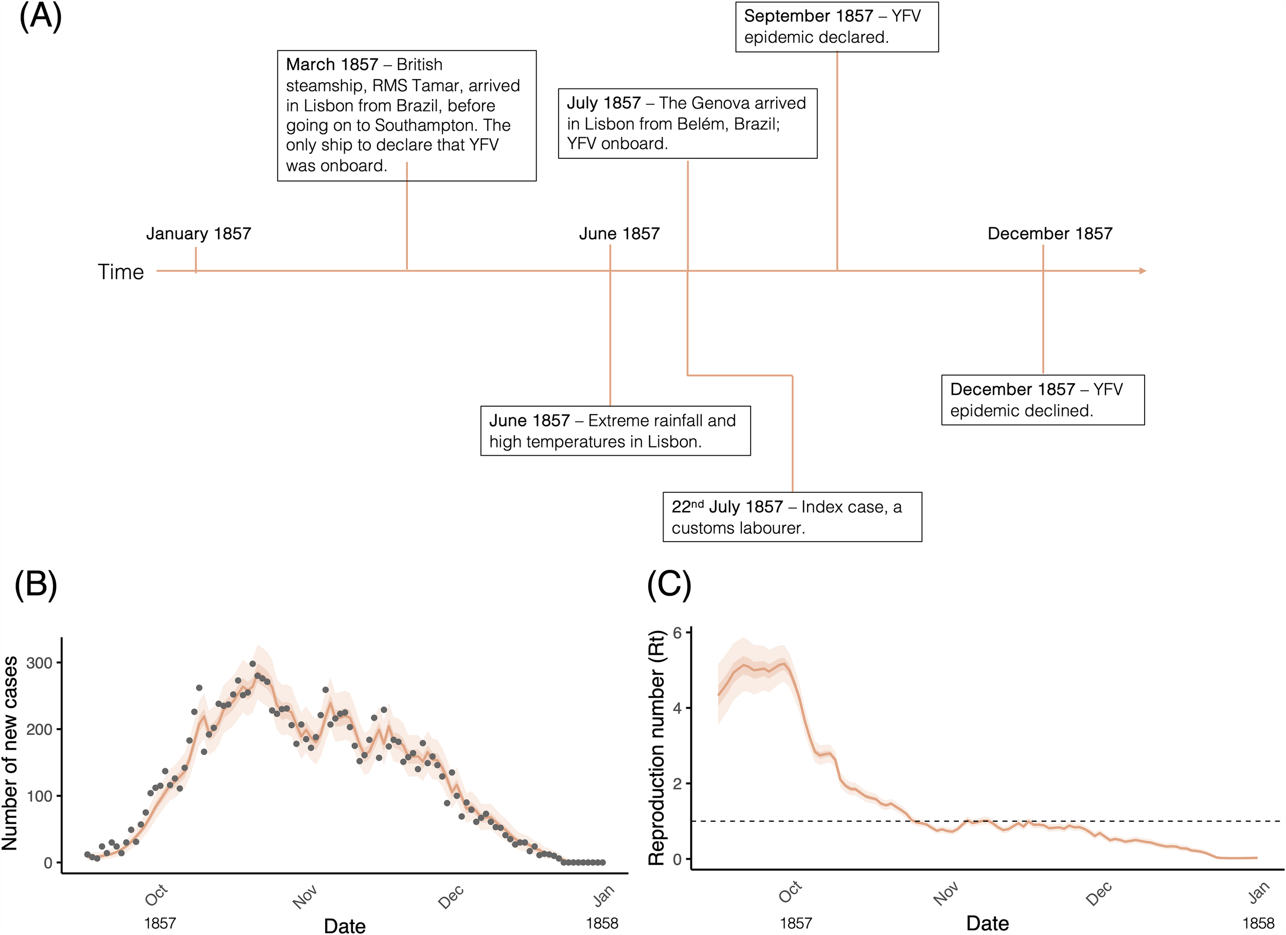
Figure. (A) A timeline illustrating the key events of the YF epidemic (B) Daily reported cases (grey points) and one-step-ahead incidence prediction (orange line) with 95% and 50% credible intervals (orange shading). (C) Rt estimates (orange line) with 95% and 50% credible intervals (shaded region) over time. The horizontal dashed line marks the epidemic threshold (Rt = 1).
Context
Our new open‑access study, published in PLOS Neglected Tropical Diseases, reconstructs one of nineteenth‑century Europe's most severe but understudied health crises: the 1857 yellow fever epidemic that killed roughly 5,650 people in Lisbon over four months. By digitising parish‑level archival records and combining them with modern spatial‑epidemiological methods — reproduction number estimation, hotspot analysis, and a digital terrain model of the city — the study shows how geography, climate and social structure together drove who lived and who died in a pre‑vaccination outbreak.
The work matters now because the conditions that allowed yellow fever into Lisbon in 1857 are returning to Europe. Aedes aegypti has re‑established on Madeira, Aedes albopictus was first detected in mainland Portugal in 2017 and reached Lisbon in 2023, and a warming climate is expanding the suitable range for both vectors. Reconstructing how a historical European epidemic actually unfolded — at the parish level — gives modern preparedness planning a concrete template for the kinds of urban gradients, occupational exposures, and environmental thresholds to watch. This work supports DeZi's broader mission of strengthening surveillance and modelling for arboviral threats across endemic and re‑emerging settings.